The Anchor and Horseshoes Pub

Moira McQuaide history of Burpham

Now the only pub in Burpham, despite the growth of the community over the last century, the Anchor and Horseshoes has a long history. The name of the pub has varied over the years, but always included either Anchor or Horseshoes or both. But how old is it?

A map from 1675 seems to show two pubs on the London Road in Burpham, in approximately the right places to be the Anchor & Horseshoes and the Green Man, so could the pub be one of the two oldest buildings in the village?

The earliest paper records show that George Heath was the Licensed Victualler, or publican, in 1785, followed by his son James until 1826. The family ran two business – the pub and the village blacksmith. From the 1830s William Baker ran the pub, with his wife Lois, who was James Heath’s daughter. After William’s death she went on to run the business with her second husband, James Alllwright, but after his death she continued as publican on her own for another 35 years. She was the last of her family to own the pub after more than 100 years and was buried at St Luke’s Church in 1889.

“…having accommodation for travellers and persons requiring refreshment other than drink; stabling provided; for the use of the general public.”

Lois’s son William inherited the pub, but wasn’t interested in running it, so he leased the business to the Guildford brewers Lascelles Tickner. Later it was sold to Farnham United Breweries, who were taken over by Courage & Co in 1927. In 1892 the pub was described as“…having accommodation for travellers and persons requiring refreshment other than drink; stabling provided; for the use of the general public.” In 1904 it had four bedrooms and stabling for four horses. Managers came and went but the Lintott family ran the pub for almost 30 years in the mid 20th century.

A road traffic improvement scheme in the 1930s proposed putting a new road through the pub garden, which would have left the building marooned on an island between two roads. In 1954 a small plane crashed into the garden, when Kenneth Owen’s Gemini aircraft’s wing hit a row of trees and was almost sliced in two. The pub became a useful meeting place for finding tradesmen of various sorts, and it was often the starting point for stag nights for young people.Over the years it has been extended and renovated several times. However, if you look at the side of the building, from the main car park, you can see the timber frame building in the external walls, suggesting that the original pub was built earlier than 1700.

If you are willing to share your memories and/or photos to tell us more about Burpham then please contact Moira MacQuaide, either by e-mail (moira.macquaide@gmail.com) or by phone or text (07963 756543). My two books (‘The History of Burpham Primary School’ and ‘Burpham – A Gateway to Guildford’) are still available from me for £10 (free delivery locally) or on Amazon.


Grand Opening of Sutherland Memorial Playing Field 1956

Moira McQuaide history of Burpham

Land from Bower’s Farm was given by the Duke of Sutherland in September 1954 to the Mayor, Alderman and Burgesses of the Borough of Guildford as Trustees, “to hold in Trust for the perpetual use as a public recreation and playing field as a War Memorial to the residents of Burpham who were killed on active service during the late war”.

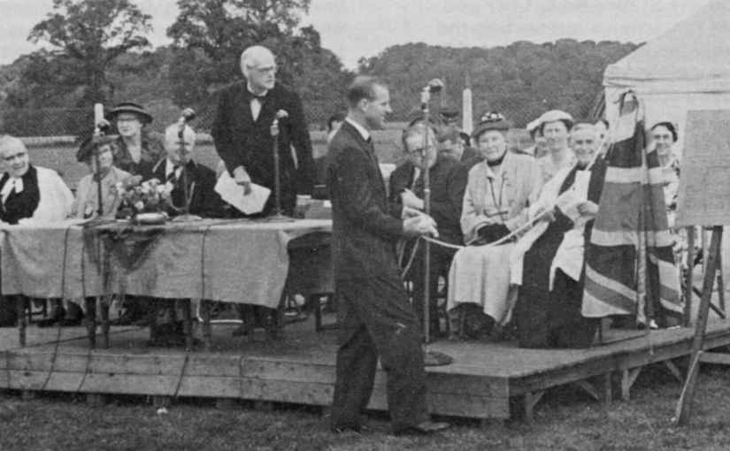
It nearly didn’t happen as The Times reported in 1956 that a petrol station wanted some of the land, but it was decided that the residents had a right to be heard and eventually they won. On Wednesday 27th June 1956 there was a Grand Opening Ceremony, when the Duke of Edinburgh arrived, flying his red helicopter, then got out of the wrong side and completely missed the Guard of Honour waiting to greet him. The Duke unveiled a plaque, planted a tree and talked to many of the children attending the event, before flying off again. In the afternoon there was a Grand Fête, with a fancy dress parade, police dogs, races, bands, sideshows and dancing. A fun day for everyone.

John Saxton was Chairman of the SMPF Management Committee for many years and he kept the spade used by the Duke to plant the tree, apparently a Blue Atlas Cedar, cleaned it up and it has never been used since. Unfortunately it wasn’t engraved, but it is still as good as sparkly new. The football and cricket clubs used the playing field and children used the recreation area. Over the years the playing field was developed and improved, the public area was extended, more trees were planted and more facilities added.

Sadly, it seems that the Duke’s tree was replanted at least four times and it’s not known if it survived. Today there are facilities for football, cricket, bowls and tennis, as well as meeting rooms and a well-equipped children’s playground and lovely green spaces. The car park is well-used, both by parents dropping off children to school or nursery, users of the facilities, or even, on occasion, vans for film crews who are filming nearby. There have also been instances when travellers have parked up on the field, needing to be removed by police. Sutherland Memorial Park received the national Green Flag award in 2005.

In memory of John and Sheila Saxton, keepers of the Duke’s spade for over 60 years.

If you are willing to share your memories and/or photos to tell us more about Burpham then please contact Moira MacQuaide, either by e-mail (moira.macquaide@gmail.com) or by phone or text (07963 756543). My two books (‘The History of Burpham Primary School’ and ‘Burpham – A Gateway to Guildford’) are still available from me for £10 (free delivery locally) or on Amazon.
 

Weybrook Park

Moira McQuaide history of Burpham

Today a popular residential estate, the area known as Weybrook Park was originally part of the forest that covered Surrey before being encompassed in local farm land. Now we see some of the few remaining areas of green space in the area subject to local concern.

This area of Burpham is currently in the local news, due to the planning application by Sainsbury’s to extend their building by cutting down over 60 trees in the neighbouring copse. There have been many objections to this, but perhaps this is a good time to look back at the history of the area.

In the 12th century, King Henry II reduced the whole of Surrey to the state of a forest, part of the Royal Forest of Windsor, but over the next few centuries the woodland disappeared as smallholders and farms took its place. Most of the Tudor buildings still in the area were part of large farms. The earliest map showing details of woodland is the Tithe Map of 1838, and you can see the area called The Coppice, which looks like a three pronged fork, of woodland around the fields that became Bower’s Farm. The land between Burpham Court Farm and London Road, and between the Wey Navigation and Burpham Lane, was farmed by William Francis Pimm, who lived at Marlyn’s, during the early 19th century. He owned some of the land, but leased other parts, including this area, from the Earl of Onslow. William died in the 1840s and over the next 40 years the farmland was split up.

Tithe Map of 1838

Bower’s Farm was first mentioned by name in the 1881 census and during the following years was farmed by Thomas Slaughter, George and Percy Gatley, Leo Keene and his daughter Dorothy Jones. By 1913 much of the woodland had disappeared, including the three prongs, leaving only the triangular plot behind the current store. There were planning applications in the 1960s for residential developments on the farmland, and both Sainsbury’s and Asda had an interest in the land. In 1982, the Surrey Advertiser reported that an American property company owned the land, having bought it from the Getty Estate in 1980. Eventually Sainsbury’s won the battle of the supermarkets. In 1984 there was an agreement between Guildford Borough Council, J Sainsbury plc and New Ideal Homes Ltd. Sainsbury’s appeared to own the land and the property developers purchased those parts not designated for the supermarket – including the copse beside the current store. A planning proposal by Sainsbury’s in 1982 included plans to have a garden centre and Homebase store on the same site. The new store opened in 1985 and was extended to include a petrol station later on.

Most of the trees currently around the Sainsbury’s store are probably not the original ones, but they play a central part in protecting natural habitats, improving the environment and cutting out noise for local residents. Green spaces are important to modern day living and history shows that this area has always had its woodlands.

Bowers Farm 1869 OS Map
Bowers Farm 1913 OS Map

If you are willing to share your memories and/or photos to tell us more about Burpham then please contact Moira MacQuaide, either by e-mail (moira.macquaide@gmail.com) or by phone or text (07963 756543). My two books (‘The History of Burpham Primary School’ and ‘Burpham – A Gateway to Guildford’) are still available from me for £10 (free delivery locally) or on Amazon.


Jacobs Well

Moira McQuaide Hall’s history of Burpham (and Jacobs Well)

Dating back to the 15th century Jacobs Well has grown to be a thriving modern community that still displays some of the clues to its history. But is it actually a village and where is the well?

Where is the well?

Extensive searching has been carried out but there is still no definitive answer, though one website suggests it is in the grounds by the Catholic church of St Edward the Confessor on the edge of Sutton Place. But there are other wells in the vicinity, including near Burpham Court House, and by the crossroads of Clay Lane and Blanchards Hill. The name Jacobs Well only appeared on maps from the early 1800s, but until the early 20th Century it was part of Burpham Manor, which was a tything of Worplesdon Parish.

Jacobs Well OS map 1871

Parts of the village are very ancient. The OS map of 1871 shows that Jacobs Well was a farming community, with little else but the five farms: Hurst, Watts, Queen Anne, Queenhythe and Jacobswell. The only other big house shown was Burpham Lodge, built in the 18th Century, which was renamed The White House in about 1930.

Parts of the village are very ancient. The OS map of 1871 shows that Jacobs Well was a farming community, with little else but five farms.

On the eastern edge of the community was Burpham Court Farm, with cottages that date back to the 17th Century. On the western edge was Hurst Farms, straddling the Woking Road, dating back to the 16th Century, now two separate houses called Willow Grange and Burpham Court House. Queen Anne Farm was built as a timber-framed medieval house, probably in the 15th Century. Jacobswell Farm was originally an open hall medieval house built about 1500. Queenhythe Farm, or Queen Hive Farm, appears to be late 17th Century. Watts Farm was built around the late 16th Century.

Burpham Court House, Jacobs Well

Around the village are Whitmoor and Stringers Commons, Sutton Place, the River Wey/Wey Navigation, and Slyfield, as well as other farmland. Over the years the community has grown and the 19th Century records show there were cottages along Clay Lane. Then on the OS map of 1914 there are houses along Jacobs Well Road. This has expanded into about ten smaller roads (some named after local dignatories), and now there are well over 1,000 houses.

Is it a village?

It doesn’t conform to the old definitions of a village, which should have a church, a school, a public house and a community meeting place. The latter is a well-used Village Hall, where a range of different events take place. However, residents need to travel further afield to find their nearest church (in Bellfields), school (Worplesdon, Stoughton or Burpham), and public house (Worplesdon).

The Jacobs Well Residents Association has moved with the times, hosting a website, a Facebook page and a Twitter account, to keep everyone informed about what’s going on – a very modern approach for a community with a lot of history.

/JacobsWellResidents
@JacobsWell_UK

If you are willing to share your memories and/or photos to tell us more about Burpham then please contact Moira MacQuaide, either by e-mail (moira.macquaide@gmail.com) or by phone or text (07963 756543). My two books (‘The History of Burpham Primary School’ and ‘Burpham – A Gateway to Guildford’) are still available from me for £10 (free delivery locally) or on Amazon.


Life in Burpham during WWII

Moira McQuaide Hall’s history of Burpham

Back on the 8th May 2020 we celebrated the 75th anniversary of VE Day in 1945. Sadly, we were not able to celebrate as intended, due to the coronavirus pandemic and lockdown. However, it is worth looking back to that time to see what life was like in the village.

Merrow Lane VE Day Party (Ann Keane)

The war years saw many changes in the village. September 1939 brought evacuee children to Burpham as part of Operation Pied Piper, and some of them stayed here for the whole war. Most came from Fulham and they doubled the size of Burpham Primary School overnight. Ron Puttnam remembered coming to live with Mr & Mrs Cutt on the corner of Burpham Lane. Miss Chesterfield, the headmistress, recorded life at the school during the war, including going into the air raid shelter behind the classrooms, and the Government demanding that the iron railings around the school be given up to melt down for munitions – she steadfastly refused to do this and they’re still there today! Jean Menzies remembered playing Hangman while in the air raid shelter. Margaret Woods remembered that chocolate powder was sent from Canada for the children to take home – wonderful for dipping in fingers and licking the powder off. The children also grew vegetables in the school gardens as part of their Dig for Victory campaign.

Children of Burpham School tending their gardens, 1945.

The local Home Guard battalion had its headquarters in the Green Man, meeting upstairs in the Paddock Rooms. The Women’s Institute organised socials to raise funds for the ‘Salute the Soldier Week’ and other war efforts. Italian prisoners from the PoW camp in Merrow worked on the farms and German prisoners cut the hedgerows. Barbara Stone remembered that all the houses had blackout curtains on the windows, and all the children were issued with gas masks – hers was a Mickey Mouse one. Many houses had air raid shelters dug into their gardens and the air raid siren was at the Kingpost on London Road.

There were 11 names on the WW2 side of the War Memorial at St Luke’s Church. Four of them lived in Orchard Road. Aubrey Collins, James Cross, Norman Drake, Jack Dunn, Clive Hammond, Harry Hirst, Derek Lord, Kenneth Percival, Frederick Ranger, Samuel Reid and Peter Vickery. All but three were under 25 years old.

So far there have been no memories told about VE Day parties in Burpham, with the exception of a street party for the children during the day and a dinner and bonfire in the evening on Merrow Lane. Barbara Stone remembered going to London with her mother to join in the celebrations there. In June 1945 the Duke and Duchess of Sutherland held a garden party at Sutton Place, to which many Burpham residents were invited.

If you are willing to share your memories and/or photos to tell us more about Burpham then please contact Moira MacQuaide, either by e-mail (moira.macquaide@gmail.com) or by phone or text (07963 756543). My two books (‘The History of Burpham Primary School’ and ‘Burpham – A Gateway to Guildford’) are still available from me for £10 (free delivery locally) or on Amazon.

Grow your own

Moira McQuaide Hall’s history of Burpham

Due to the Coronavirus lockdown perhaps we will be encouraged to grow our own food in the future?

Apparently the amount of land for allotments has dropped by over 50% since the 1960s. Getting fruit and vegetables from supermarkets has become the focus of panic buying. The Burpham allotments in Bower’s Lane might be an alternative – they are managed by the Guildford Allotments Society, with a local site representative to manage the area and sort out day to day issues.

The 1914 OS maps showed Allotment Gardens behind Burpham Primary School, edged by the river on one side, Burpham Lane on the other, and extending down to the old brick field next to Pimm’s Row. In the 19th century and earlier most houses had a small garden where some vegetables could be grown. According to records in the early 20th century Burpham had several market gardeners, smallholders and nurserymen, presumably many of them used the allotments, including the Kemps, Kilbys and Russells. Residents in Pimm’s Row grew produce in the gardens in front of the cottages. Leonard Vincent, who was a market gardener well into the 1960s, donated some of the land by his house in Bower’s Lane to the Council for allotments.

The 1934 OS map showed Market Gardens still there beside and behind the school. During the war the children were encouraged to grow vegetables, then after the war some of the allotment land was taken to provide a playing field for the school. However, the school lost some of that land when the A3 was built in the 1980s.

In 2007 there was a spate of attacks on allotments around Guildford. A Surrey Live report said: “The devastation at Burpham was unbelievable. It was like a First World War battlefield. They had chopped the greenhouses to bits. It was a mess.” It seemed that the black market value of aluminium was the cause, but the result was improvements to the fencing around the site and a locked gate. One of the Burpham allotment plots was the overall winner in the Guildford in Bloom 2015. There are vegetables, fruit, flowers, sheds, greenhouses, cages and polytunnels – even the occasional table and chairs for those social or rest moments.

Allotments in Burpham

As I look out at my garden I have to wait for months for the fruit to ripen and I don’t have any vegetables – yet! Perhaps allotments will come into a new heyday as a result of the virus. If you don’t have an allotment then perhaps the Gardening Club could help you transform part of your garden? It could be good for all of us.

If you are willing to share your memories and/or photos to tell us more about Burpham then please contact Moira MacQuaide, either by e-mail (moira.macquaide@gmail.com) or by phone or text (07963 756543). My two books (‘The History of Burpham Primary School’ and ‘Burpham – A Gateway to Guildford’) are still available from me for £10 (free delivery locally) or on Amazon.

Burpham Village Hall

Moira McQuaide Hall’s history of Burpham

The Village Hall is an important part of any community, a place to meet people, to organise events, or to raise funds through lettings.

Norman Hamilton wrote that it was “built in 1922 from surplus war materials auctioned at Thursley Camp”. The Burpham vicar at the time heard about the sale of a building that would be suitable for use as a village hall. It had been a wooden hospital ward, with a dispensary attached, imported to take Canadian casualties, but had never been used. The vicar, and local farmer George Gatley, arranged for it to be brought over to Burpham to be erected next to the Church Room on Burpham Lane. Unfortunately, due to heavy rain, the transport lorry got stuck in the muddy grass and for several months the pieces of the building lay on the grass before it could be put together.

The land was leased from the Duke of Sutherland for one shilling a year and Mrs Marshman was employed as a caretaker, earning nine shillings a week. Minor maintenance was carried out by members of the committee. Heating was provided by two tortoise stoves, but electricity was not installed until 1935, after the Women’s Institute held a jumble sale to help pay for the new facilities. The Trustees for the Village Hall in 1923 included two Mr Binsteds, Mr Kerr, Revd Storr and Mr Gatley. Mr Bidwell was Honorary Secretary.

The Burpham vicar at the time heard about the sale of a building that would be suitable for use as a village hall. It had been a wooden hospital ward, with a dispensary attached, imported to take Canadian casualties.

Circa 1947: Children of Burpham Primary School (including evacuees) outside the Village Hall.

In 1940 the lease was extended for a further 99 years, but the rent stayed at one shilling per annum. Over the years there have been further developments to the hall, which now includes a large room and a small room, modern fitted kitchen, toilets and parking.

In the early days there were Friday Whist Drives, which were very popular before the advent of television. The Women’s Institute and Mothers’ Union held their meetings there and it was a venue for weddings and parties – though they had to overcome the convention that strong drink should not be consumed in the hall. During World War Two it was used for Mrs Stock’s mother and baby clinic, and pupils from Burpham Primary School had their lunches there. These days it provides a very popular venue, with users including the Gardening Club, WI, and a number of other organisations. U3A holds many of its group meetings in the two halls, across a wide range of subjects, including languages, engineering, arts & crafts and history.

For hire of Burpham Village Hall contact Dave Jepson on 07752 549313.

If you are willing to share your memories and/or photos to tell us more about Burpham then please contact Moira MacQuaide, either by e-mail (moira.macquaide@gmail.com) or by phone or text (07963 756543). My two books (‘The History of Burpham Primary School’ and ‘Burpham – A Gateway to Guildford’) are still available from me for £10 (free delivery locally) or on Amazon.

New Inn Farmhouse

The oldest surviving building in Burpham

Moira McQuaide Hall’s history of Burpham

Now the oldest surviving building in Burpham, New Inn Farmhouse dates back to at least the 1600s, with later extensions and alterations. The origin of the name has been lost in the mists of time – was it an inn at some point or did the name reflect a new inn nearby?

1869 OS map showing New Inn Farmhouse

It was shown on a map of 1690, but by the early 1700s it was a working farm, run by John Atfield. Lord Onslow bought most of the land in Burpham from Robert Wroth in about 1720 and continued to own it until the early 1900s. The farm land extended back from London Road to where the railway line is now and from New Inn Lane across to almost the Anchor and Horseshoes pub. It was quite common for one farmer to either own or rent farm land across wide areas and in 1841 William Francis Pimm, who owned Marlyn’s, farmed New Inn Farm as well as much of Weylea Farm and part of Bower’s Farm. By 1887 it was recorded as being part of Winterhill Farm.

In 1905 Lord Onslow put the farm up for sale and it was described as “An attractive dwelling house, built of brick with partly tiled walls and tile roofed. It included an attic, four bedrooms, bathroom, two boxrooms and WC on upper floor. On the ground floor there were two good sitting rooms, kitchen, scullery, dairy and larders. There was also a garden and orchard.” William Winzer was the last farmer to work New Inn Farm, from 1915 to about 1950. The land was sold to a developer in the early 1950s, who created a housing estate, with police houses, and George Abbot School. In later years the Church of the Holy Spirit, Burpham Homes and many more houses were also built on the old farmland. The farmhouse was sold in 1952, along with outbuildings including stables and “a small hovel”. Other farm buildings were sold separately.

Sales particulars for New Inn Farm 1905

In the late 1960s the farmhouse was sold again, described as “A 16th century old-world Surrey farmhouse…having quaint low beamed ceilings and brick fireplaces.” It was bought by Dr Derek Parkin, to be the doctor’s surgery for the next 20 years. Then Dr Leon Barbour bought the building and took over the surgery. After his retirement he continued to own the building but the surgery was run by other doctors, and latterly with the chiropractic clinic in one part of the house. Sadly, the surgery has now closed and there is no longer a GP in Burpham. Time will tell what happens next in the story of this historic building.

If you are willing to share your memories and/or photos to tell us more about Burpham then please contact Moira MacQuaide, either by e-mail (moira.macquaide@gmail.com) or by phone or text (07963 756543). My two books (‘The History of Burpham Primary School’ and ‘Burpham – A Gateway to Guildford’) are still available from me for £10 (free delivery locally) or on Amazon.

The Village Pond – or is it?

Moira McQuaide Hall’s history of Burpham

Some people may be aware of the pond between the top of New Inn Lane and Merrow Lane. Most of the time, if you’re driving past, it is shrouded in the foliage and almost impossible to see. In the winter it is a bit easier to find.

The pond appeared on old Ordnance Survey maps in the 19th century, so has clearly been there for a long time. But is it a village pond? If so, then it’s rather out of the way, on the extreme edge of the old village, and almost in Merrow – in fact, until the coming of the London Road railway line, it was actually in Merrow parish.

1895 OS map showing pond in woodland on New Inn Lane.

In 1975 the BCA started a project to free up the area and used the George Abbot boys’ school Conservation Society to help clear the pond. Then in 1986 the BCA reported on another conservation project to clean and restore the pond. The headlines in the newsletter read ‘The Village Pond – Burpham’s best kept secret’.

The plan was to introduce plants and fish into the pond, which was already a habitat for newts, frogs and dragonflies, along with occasional visits from mallard ducks and deer. In about 2004 the BCA again reported that the pond was to be restored, but nothing seems to have come of this as there were no further reports.

The ‘Village Pond’ in 2016 (Photo: T Bass).

To the romantics among us it is nice to think that this was a village pond. Indeed, some people remember that it was a good place for young people to meet up in the woods by the pond, known as Middle Oak. However, a rather more practical suggestion has been that it was probably a traction engine water replenishment pond. Not quite so romantic an idea. Traction engines started to appear in the UK around the 1850s, so given that we have no earlier maps showing the pond this might be the correct answer. To this day there are still occasional traction engines to be found on the roads, but I don’t think they would be filling up with water from the Burpham pond. Stopping on that narrow bit of road would create even more traffic gridlock than we have at present.

If you are willing to share your memories and/or photos to tell us more about Burpham then please contact Moira MacQuaide, either by e-mail (moira.macquaide@gmail.com) or by phone or text (07963 756543). My two books (‘The History of Burpham Primary School’ and ‘Burpham – A Gateway to Guildford’) are still available from me for £10 (free delivery locally) or on Amazon.

London to Portsmouth – via Burpham

Moira McQuaide Hall’s history of Burpham

The village of Burpham grew up around the London Road as this was the main route between London and Portsmouth. Well used by the Royal Navy and other travellers, coaches and riders came through Ripley, Burpham, and on to Guildford on their way south to the coast.

A 1603 map showing the London Road.

From 1555 to 1835 responsibility for maintenance of the Burpham stretch of the road fell to Worplesdon Parish, which included the Manor of Burpham. After the Wey Navigation opened in 1653 much of the heavier freight traffic moved to the waterways, then again with the coming of the railways in 1845, traffic moved away to the trains. In the 18th century Turnpike trusts were formed so that toll fees could be collected and the money used to maintain the roads. In Burpham the toll gate, Green Man Gate, was between the New Inn Farmhouse (now the doctors’ surgery) and the Anchor & Horseshoes pub.

In 1889 the new Surrey County Council took responsibility for main roads. Motor cars gradually replaced horses towards the end of the century, and as they became more popular the speed limit was raised to 12 mph by 1900, and speed traps were brought in for the London Road. By 1905 tar macadam was used on surfaces, improving the quality of the roads. World War One brought an increase in traffic, due to troop movements, which damaged the road surfaces. In the 20th century road haulage increased, especially with the creation of motorways.

The A3 passing the original sites of The Parkway and Ladymead.

In 1934 the Guildford and Godalming bypass was opened, taking traffic to the side of Stoke Park, now Parkway and Ladymead, but this didn’t reduce the number of vehicles coming through Burpham. The sixties and seventies saw further plans, potentially dividing the village in two, by knocking down Pimm’s Row, and isolating both the Burpham pubs. Following objections from local residents, another plan was agreed, taking some of the Primary School’s playground, and cutting off the old Jacob’s Well Road.

The new A3 road, diverting the London to Portsmouth road around Guildford, with slip roads off at Burpham, Dennis’s Roundabout and the Cathedral, opened in 1981. On Charles and Diana’s wedding day a tug of war was held on the empty road between teams from the two Burpham pubs.

Today the traffic problems on London Road have increased. Commuters approaching East Guildford leave the A3 at Burpham, Aldi shoppers queue for the car park and many cars queue through Burpham to get onto the A3 north. Can this be improved in the future? It remains to be seen.